- Camping is permitted throughout this wilderness area, but campers must follow the guidelines set with the Sulphur Ranger District: 970-887-4100.
- The 23 miles' worth of trails are largely above timberline, offering hikers some of the best ridge hiking and scenic views in the state.
Overview
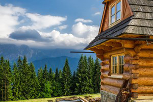
The Byers Peak Wilderness is a special area within the Arapaho and Roosevelt National Forests; it encompasses a wide variety of terrain over its nearly 9,000 acres, featuring mostly alpine tundra, along with pine forests and drainages, two glacial lakes, three creek drainages, and two peaks over 12,000 ft. Byers Peak, the highest of its two peaks, topping off at 12,804 ft., was named after William N. Byers, a former mayor of Hot Sulphur Springs and the founder of the Rocky Mountain News, Colorado's first newspaper.
Below timberline, you can expect to see huge Engelmann spruce, fur and pine trees. Bear, moose, elk, mule deer, mountain goats and big horn sheep roam this pristine wilderness area, and it's common to spot marmots and ptarmigan while hiking. It shares a common border with the Vasquez Peak Wilderness - both are separated by the Fraser Experimental Forest, and to the south lies the Williams Fork-Ptarmigan Peak roadless area.
Location
There is an East and West access point:
East Access (the easiest from the Winter Park/Fraser Valley): From US Highway 40, drive North toward into Fraser. Turn left at the traffic light in the center of town (adjacent to Safeway), onto County Rd. 72. and drive for .2 miles Turn right onto the Fraser Parkway for .8 miles, and then turn left onto County Rd. 73 and drive for about 7 miles and it turns into Forest Road 160.2. Follow this to trailhead - pass the 1st 'Y' in the road, and at the second 'Y', make a sharp right onto Forest Rd 111. You'll see a Byers Peak Trailhead sign - follow that road until you get to the gate.
West Access (near Parshall): From Winter Park, drive Northwest on US Highway 40 and continue on toward Granby and then into Hot Sulphur Springs. Keep driving through Hot Sulphur Springs and through Byers Canyon. Between mile post 197 and 198, turn south onto County Rd. 3 and watch for mile marker 15. Right after mile marker 15, you'll see County Rd. 32. Take County Rd. 32 for 4.7 miles and then turn right onto FR-136 (marked for Lake Evelyn and Bottle Pass Trail). Drive another 4 miles until you reach the trailhead parking lot.
Activities
Hiking and sightseeing are the primary attractions, and the 23 miles worth of trails are largely above timberline, allowing for extensive ridge hiking that affords some of the best panoramic views in the state. The Byers Peak Trail traverses the entire length of the wilderness, from Bottle Pass to St. Louis Peak.
Hiking Trails
- Byers Peak Trail: This is the most common trail used for a great day hike; this trail is steep (a 3000 foot elevation gain) but short, and you'll cross Byers Creek at the beginning and then continue to traverse the forest as it leads to the summit of Byers Peak. This trail is accessed from the East access point, and it traverses the entire length of the wilderness, from Bottle Pass to St. Louis Peak.
- Old Bottle Pass Trail: This trail loops into the New Byers Peak Trail, with the summit 3.8 miles away and has a 3,000 foot elevation gain. Also accessed from the East access point.
- Keyser Creek Trailhead: A very scenic route with less foot traffic than the eastern trails; the summit is 5.3 miles from the trailhead, with a 2800 foot elevation gain. This trail is accessed from the West access point.
Fishing
The following Byers Peak Wilderness areas are available for fishing/fly-fishing:
- Evelyn Lake
- St. Louis Lake
- West St. Louis Creek
Campgrounds
The only designated campground within the wilderness area, the Byers Peak Campground, has been closed indefinitely due to the beetle kill infestation, but camping most anywhere in the Byers Peak Wilderness is permitted; you must camp at least 100 ft. from a water source or a trail, and any human waste must be buried in a hole that's at least 8 - 10 inches deep, or double bagged and carried out. Everything that is packed in with you must be packed out.
For more information regarding camping restrictions, current road and trail conditions, contact the Sulphur Ranger District. Address: 9 Ten Mile Drive, Granby, CO 80446. Phone: 970-887-4100.