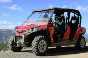
- Corona Pass is a popular destination for hikers, photographers, sight-seers, ATV and snowmobile enthusiasts, and history buffs.
- Vehicles and ATV's can drive to the summit during the summer months, but during the winter, snowmobiles are the best utilized.
- This pass was once a heavily traveled wagon road to Boulder County.
Overview
Otherwise known as Rollins Pass (named after John Rollins, who constructed it as a wagon road around 1870), Corona Pass is a mountain pass with an elevation of 11,660 feet; it is located on the Continental Divide, southwest of Boulder, and it sits about five miles above the Winter Park Ski Area (between Winter Park and Rollinsville) on the boundary of Boulder and Grand Counties. Though it was once a route into Boulder County, it is no longer passable, but with care, a vehicle can travel the unpaved road to the summit in the summer; otherwise, ATV's and snowmobiles are probably the best way to tour this scenic area.
Driving Directions
From Winter Park proper, drive south on US Highway 40 toward Berthoud Pass/Denver. About .6 miles, before the stop light near the Lakota Subdivision entrance, you'll make a sharp left onto Corona Pass Rd/US Forest Service Rd. 149. (The road up to the pass goes east from US Highway 40.)
Time/Distance
About a three minute drive to the road itself from Winter Park, with a distance of about .6 miles. Once you're driving on the road, depending on conditions, it should take about 40 minutes to reach the summit.
Highlights
This unpaved, rough road itself is generally the former roadbed of the Denver and Salt Lake Railway, but it was once a route from the Front Range into the Winter Park area, and it was used frequently to drive cattle into Grand County (or Middle Park) back in the late 19th century. As soon as the Moffat Tunnel opened in 1928, this route was abandoned. Due to tunnel closures and road washouts, the pass is no longer accessible from the East. Now it's a popular location for hikers (due to the views and beautiful wildflowers, etc), ATV'ers, and hunters (during designated hunting seasons), and during the winter, it's a paradise for snowmobilers and snowshoers. Near the summit, Riflesight Notch, which is an old railroad trestle, is a cool sight to see, and the views of the Continental Divide are unmatched. The Continental Divide National Scenic Trail, also known as the "King of Trails", can be accessed from this pass; drive to the summit and you'll see the trail head signs.